
Neil Peart has spilled gallons (OK, milligrams) of ink writing about his high estimation for the great detail and superior reliability of Rand McNally maps when planning his concert tour motorcycle journeys.
Tying the world's greatest living drummer into this series of local history postings and the Rand McNally map would be easy enough under ordinary circumstances for a big Rush fan such as your diligent correspondent. It helps that the Canadian Power Trio have undertaken in recent years a concert tour titled "The Time Machine Tour" [2010-2011]. It also helps that I'm currently reading Peart's most recent - but hopefully not his last - book, Far and Wide (published in 2016). One vividly evocative verse in the Rush song "Dreamline" [1991] draws together the loose thematic threads into a tightly knit patchwork:
Time is a gypsy caravan
Steals away in the night
To leave you stranded in dreamland
Distance is a long-range filter
Memory a flickering light
Left behind in the heartland
These blog themes of time and memory - and with the introduction of this 1923 map - distance (literal and metaphoric), as well as long range reconnaissance and the Heavy Artillery email down range notifications all are distilled into that one pertinent (Peartinent?) verse like a fine Macallan whisky..... the favored end-of-ride quencher for Neil Peart.
This (near) mint-condition gem of ephemera I purchased for myself. I opened the pocket-sized booklet once, early in 2016, gently unfolded its expansive sharply creased two-sided color map, photographed some of the elements that were relevant to my interests and then carefully re-folded the map and put the booklet away in dry, moderately warm safe storage.
One aspect of these old maps which fascinates me are the place names which have all but vanished from living memory, save for the occasional name found on remote country roads. The map below shows railroads and electric traction lines of Butler County in 1923;

Just northwest of Oxford, midway between the home of Miami University and College Corner, is Donald, OH. Show of hands; who knew? Head northwest out of Oxville on US 27, turn left onto Ringwood Road, and stop near (not on!) the railroad crossing and there you are in Donald, OH. Could not have ever been more than a train depot.
South of Reily is Newkirk, OH. Featured here in these digital pages some time ago, to find Newkirk head south out of Reily on Ohio 732, turn west onto Dunwoody Road, stop near (NOT ON!!!) the railroad crossing and there you are. Perhaps nothing more than train depot, yet there have long been a smattering of homes in the immediate vicinity so it might once have had aspirations of being a village.
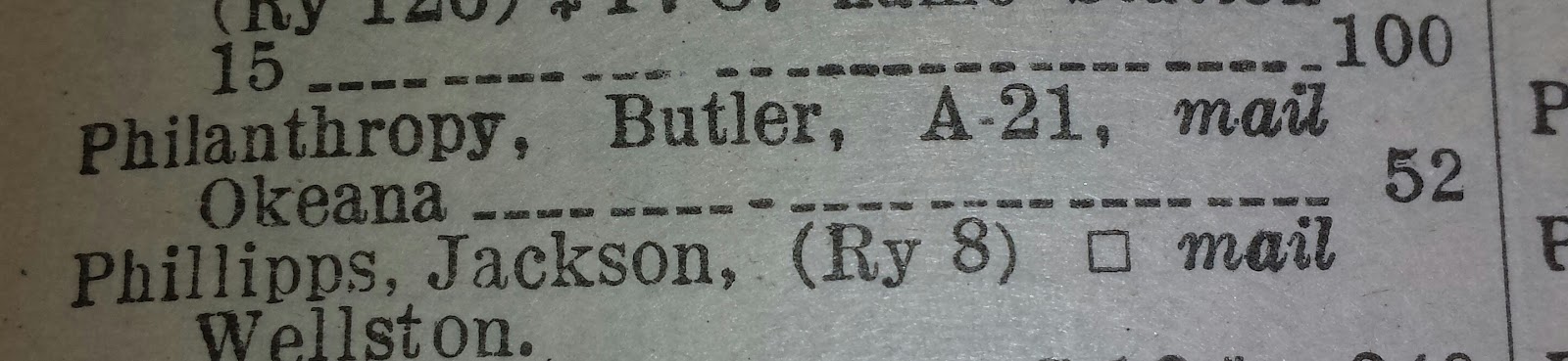
Philanthropy is the Ohio portion of Scipio, Indiana, hard on the Ohio-Indiana state line. That was and remains a very small community of homes and businesses.
Woods is recognized today as the northern terminus of Bunker Hill Woods Road, the name Woods coming from the one-time existence of Woods Station. Like Newkirk, the remnants of homes collected close together is suggestive of a once-nascent community.
Contreras we also know in these modern times as a road name leading west out of Oxford for the Ohio-Indiana state line. Records indicate that for a brief period, long ago, a post office existed in Contreras. Probably not much else.
Midway, found mid-way between Hamilton and McGonigle? I haven't tracked that one down yet.
The rail line leading westward out of Hamilton, through Oxford and into the terra incognita of wild, untamed Indiana - annotated in red ink by Rand McNally as "39" on the map - was the Cincinnati, Indianapolis & Western RR.

The C.I.&W. RR sounds like an undiscovered area of memorabilia collecting.

US 27 south from Oxford was originally routed through Dunlap circa 1926. Dunlap still exists today and can be accessed via a fun twisty & hilly drive on Old Colerain Rd (formerly US 27). In more recent decades, US 27 south of Ross (aka Venice) was realigned and widened into a divided multi-lane highway to the east of Dunlap. US 27 runs today through Bevis, OH. The next time you find yourself stuck at the traffic signal at US 27/Colerain Ave and I-275, look over at the cemetery and spy all the Bevis family names on the headstones there.
For those who didn't know, Fernald existed long before the Cold War.

Some locales in East Indiana, alias Preble County, today barely cling to maps and memories; Ingomar, Sugar Valley, Euphemia. Some have vaporized into the ether; Ernest, Ebenezer, Progress.

My Irish grandmother's paternal grandparents emigrated from the Emerald Island sometime around 1865, miraculously surviving the worst years of The Great Famine, and settled in Springfield, OH that same year. [My grandmother's maternal ancestors - also Irish - arrived in the United States at points earlier in the nineteenth century and contributed two men to Abraham Lincoln's Union army.] The family didn't stay rooted within Springfield's city limits for very long before railroad and limestone quarry work opportunities led them to a series of successive residences immediately north, then later immediately west of town.
Sometime around 1890 the family took up their first extended residential stay in one place when they moved to Durbin, OH, then and now a small collection of homes on either side of the Lower Valley Pike, along the Mad River. At about the turn of the twentieth century the family then moved the short distance to Cold Springs. Cold Springs is alternately identified in period sources as Cold Springs Station - it couldn't have ever been much more than a train depot. A distance of only about 1,000 feet and the Mad River separates the old train depots of Durbin and Cold Springs Station. A few old, small houses still remain in Durbin. No obvious evidence of Cold Springs as a community remains in existence, neither on the landscape nor on modern maps. My ancestors remained in Cold Springs for just a few years, at most, before moving back into the city of Springfield by 1905 or 1906.
The Rand McNally Pocket Map index reported a 1923 population in Durbin of only 55.

It is fair to think that Durbin wasn't ever much larger than that. Note the even smaller populace in Dunlap, and at a time when a federal highway was being planned to run right through the middle of that village.

Oxford certainly did merit a population figure by Rand McNally in 1923;

The Oxtown population then was a scant 2,146. This year's Miami University freshman class approached a sum nearly twice that.
Springfield boasted a booming population in 1923;

The population in the vicinity of Woods/Woods Station may be similar in 2018 to the number published by Rand McNally in 1923;

College Corner may or may not have experienced a residential boomlet during the Calvin Coolidge years. Who could tell?

Bevis counted just over two dozen inhabitants;

Philanthropy must have been bursting its seams with two score and four more;
Scrappy Ingomar benefited from having a railroad running through town and thus scoffed at humble Bevis and modest Philanthropy;

Hee Haw salutes Reily, Ohio [in 1923]. Population 400;

Sal-ute!
Roll the credits!